Day Eight

DSC_0190

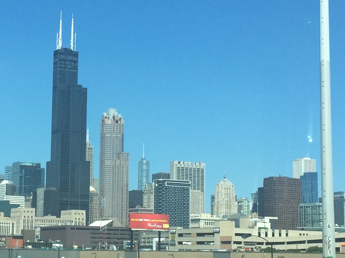
Our first thought was, “Oh my God…how did it get to be day eight already????” To say that this first week on the road has flown, would be an understatement. When you think of the miles we have traveled, the places we have seen, the great meals we have had, and the experiences we’ve shared, you’d think that these past 8 days would have seemed like an eternity, but it really hasn’t. The daily drives have been very manageable, the hotels we’ve stayed in have by far been fine, and the things we’ve seen have really been spectacular. How could we ask for anything more!

This morning we woke in Cody, Wyoming and here’s a secret of our travels…we don’t wake to an alarm! We get up when we get up. Both Susie and I have spent too much of our life needing to wake up with an alarm, and we refuse to do it on this trip…unless we absolutely have to! So we got up, went and partook of the free breakfast at the hotel, and then got in the car and headed the 50 miles to the East Entrance of Yellowstone National Park. Now Yellowstone is the first, and therefor, the oldest National Park, and since we are still in the NPS’s 100th birthday weekend, again there was no charge to get in…another day without being able to use my Senior Pass!!

DSC_0196
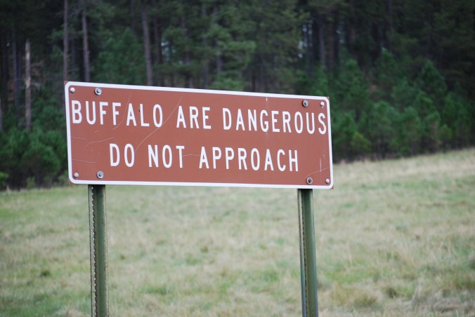
We were less than 2 miles into the park when the traffic stopped dead. We had no idea why, until we rounded a curve and found out why. Coming down the double yellow line in the road, like he was doing a sobriety test, was the largest bison we’d ever seen. He continued to amble down the road until he passed about 3 feet away from the car, and we all went on our way! Talk about seeing wildlife!!! Then we continued to Yellowstone Lake, which is huge! We are staying for 2 nights in the Yellowstone Lake Hotel, and it is both old (it opened in 1891) and beautiful…but more on that later.

DSC_0238.JPG

DSC_0226Our destination this afternoon was Old Faithful Geyser. As we traveled from the Lake area of Yellowstone to Old Faithful, we passed over the Continental Divide, twice in each direction. Amazing to think that rain on one side eventually drains to the Atlantic, and on the other side, the Pacific. I actually thought the first time we’d see it was in the Rockies, but Yellowstone has it all!

I don’t know what’s the more amazing thing about Old Faithful…that it erupts about 130 feet in the air, and has been doing it since it was first discovered in the 1800s, or that it does it with such regularity that they actually have a schedule for it!! 3:02 plus or minus 10 minutes was what it was scheduled for this afternoon, and right on the money at about 3:04, erupt it did! Crazy! The other crazy thing is how rude and selfish some people are. We went out to the viewing area and grabbed a front row (benches) seat at about 2:30. By 2:50, the place was full of people, but minutes before the eruption, here come a bunch of folks who decided they should sit on the ground in front of us. Yeah, I really want your head in my picture folks!! Guess what…most of them were not English speaking tourists! Ugly Americans my ass! We are some of the nicest, considerate folks you will run into, but watch out for the tour busses of foreigners! Rant over!

imageAfter the eruption, we returned to the hotel and got changed for dinner. We had 5:30 reservations in the Lake Hotel Dining Room, and felt we should get out of the shirts and t-shirts befitting eating in a nicer venue. This hotel has a real old school elegant feel to it, image
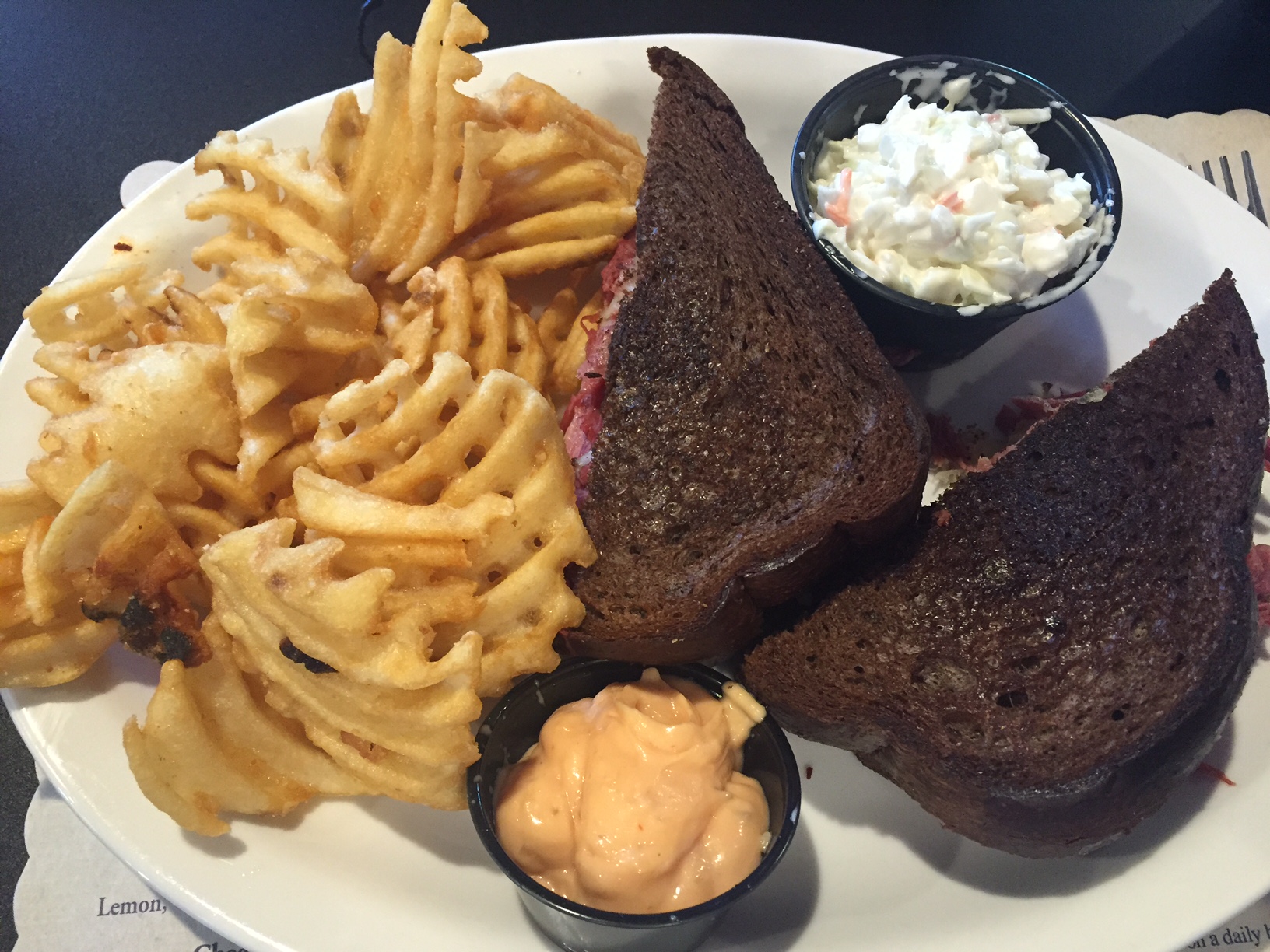
and we wanted to feel like we were upholding the history of the place in our dress. We felt good about what we did, but obviously some folks didn’t feel the same, as we saw every mode of dress! I’m sorry, but there is just something about someone eating dinner in a wonderful, historic dining room like this hotel has, in a baseball cap, that bothers me. Oh well. We had a wonderful dinner, starting with an excellent charcuterie plate, and then had an excellent Bison Filet. A nice bottle of bubbly and a couple of scrumptious desserts rounded out a really excellent meal!

IMG_4217.jpgAfter dinner, we sat on the front porch of the hotel for a bit, looking at the lake, then came inside and sat in the lounge. We had a couple of drinks, listened to the lady playing the piano, had a nice conversation with a couple from the UK, and wrapped up our day in a great way!

Tomorrow we may have to set an alarm (oh God, no!!!) because we have a cruise on Lake Yellowstone at 9:15 AM. Then we have the middle of the day to explore the park, and we end our day with a Yellow Bus Sunset Tour! Looking forward to another great day!!

Susie just commented that this is a first for us this week. We have a very nice room, but there is no TV and no air-conditioning! In addition, there’s no Wifi, but then we are in a National Park! If I get to post this at all, it will be via my cell phone’s hot spot, and there is no way I will be able to get pictures loaded. So if you see this sans pictures, know that once we are back in wifi territory, I will share some of the great ones we took today with you!

See you tomorrow!


Day Seven

image

Today we took a brief detour from Wyoming to Montana, and had another goose bump moment thanks to our National Park Service!

We left Sheridan, Wyoming about 9 AM, and headed out westbound on Interstate 90 towards the Wyoming/Montana border. Our plan for the day was to first spend some time at the Little Bighorn National Monument in Montana, and then return to Wyoming and head towards Yellowstone National Park. The trip to Little Bighorn took us about an hour, and passed through some very desolate territory. Thank goodness we had a fairly full tank of gas when we left, because exits on the Interstate were mostly just cross roads with nothing on them. Several times after entering Montana, we crossed over the Little Bighorn River for which the battle was named.

As the National Park Service is still celebrating it’s 100th birthday, entrance to the monument was free…damn, when am I going to get to use my $10 Senior Pass again??? We parked and entered the visitor center, and after looking around the museum, we sat through a 25 minute movie, which laid out some of the reasons that led up to the battle. Then we went outside and sat through a 45 minute Park Ranger talk which told us about the battle, what happened, and why. Both were very enlightening, and gave us a much better understanding of the battle. It was very moving and a little troubling to really hear the facts of what we did, as a country to the Native Americans. Sad when you realize that the discovery of gold in the Black Hills was a pivotal episode in our treatment of the Lakota and other tribes.

Then we moved out to the actual battle field and headed up to the hill that is called Custer’s Last Stand Hill. There is a monument there that lists all that died on the hill, and under it are the aggregated remains of the enlisted men who died that day. The officers’ remains were sent home (Custer’s are at West Point), but the enlisted men were hastily buried after the battle in shallow graves. Several years later, the outrage of the American public caused the Army to return to the site, and that was when the monument was erected and the bones were buried in a mass grave beneath it. At the same time, they erected marble markers where each solder was killed. It is a very moving experience to see these white markers scattered all across the battlefield and realize that each mark was where a man lost his life.

As a country, we were very slow to recognize the Native Americans who died that day, but recently red marble markers have been erected on the battlefield to show where they died. In addition, a monument to the Native American warriors was also erected across the road from Custer’s Last Stand Hill. Slowly, as a country, we’ve recognized that these warriors died trying to defend the Native American way of life. As I said, it was a very moving 3 hours we spent there, and well worth the detour from Wyoming.

Then, it was time to head back to Wyoming, and return to our path to Yellowstone. Since I had driven up, and since we’d be returning over a lot of the same territory, Susie offered to drive and I accepted. We were back on I-90 (eastbound this time), across the Montana/Wyoming border, and 9 miles into Wyoming, we exited the Interstate. Susie had read about a road that was called “one of America’s most scenic”, and thought it would be a great way to head towards our destination for the night, Cody, Wyoming. What she didn’t read was that this road was so scenic because you drove over the Bighorn Mountains to get to Cody!! Again, driving through pretty desolate territory, the road slowly started to head into the foot hills, and before Susie realized it, she was driving over the Bighorn Mountains!! Switchback after switchback, climbing ever higher, the speed limit dropping from 65 MPH to low as 20 MPH on some of the curves, she continued. Finally we reached the top, and the sign that welcomed you to an elevation of 8327 feet! Susie admits a few sweaty hands during the climb, but she did great and she was proud of what she’d done, and so was I!

After we were about a third of the way down, we hit a rest area with bathroom facilities, took advantage of them, and I took over driving. All in all, we can see why they called it one of the most scenic roads in America, as it was beautiful, when you had the nerve to look over the side! The rest of the ride to Cody was uneventful, with a long straight road heading off into the distance (reminds me of Vanish Point), and about 4:30 we pulled into the Comfort Inn in Cody, having traveled 254 miles.

All along the trip, we have been very lucky with our choices for places to have dinner. Our food routine each day is to either partake in the hotel offered free breakfast, or to skip breakfast, and eat lunch out of our cooler. Yesterday we finished up the ham and american cheese rollups Susie made before we left, and this morning we had a very nice breakfast at the Comfort Inn in Sheridan, Wyoming. We always end our driving day with a Sailor Jerry Rum and Coke (some days, like today, they are very much needed after a particularly stressful drive), and then seek out a local place for dinner. Tonight we discovered Pat O’Hara’s Brewing Company Pub and Grill located a block from our hotel. It featured local brews and Irish Pub grub…what could be better? We started with Irish Egg Rolls and Susie had Shepard’s Pie, and I had tonight’s special…Corned Beef and Cabbage! Another good choice Susie!!

image

Notice the coaster under by “Atlantic City Lager”  

We are now about 50 miles from the East Entrance of Yellowstone National Park, and tomorrow our destination will be the Yellowstone Lake Hotel in the park, where we have 2 nights booked. Our original plans had us leaving Yellowstone via the southern entrance and then driving through the Grand Tetons. Unfortunately, a lightning strike started a forest fire in the Tetons, which is burning across the road leading from Yellowstone to the Tetons, closing that southern entrance. We keep checking the daily reports, but it doesn’t look good for us to head that way on Tuesday, so we will probably have to leave via the western entrance. Then we will loop through Idaho and head south. We may make the Tetons this trip or not. You can’t fight Mother Nature, so we will take whatever path we can come Tuesday, and not worry about it till we get there. There are too many wonderful adventures ahead of us in Yellowstone National Park!

Thanks to all who are reading this blog and following along on our adventure with us. Wish we had room in the back seat for you, but you’d have to sit on the cooler and hold our map bag on your lap! Thanks for the likes and comments on Facebook, and thanks Laurie for the message today…you made our day!

Good night all…

IMG_6063Susie and her much needed Rum and Coke tonight

Day Six….Wyoming!

image

We left the hotel in Keystone, South Dakota this morning, intending to head north to the notorious town of Deadwood, South Dakota. We had a lovely drive of about an hour through the Black Hills National Forest. The terrain was still very, what they would call out West, “hilly” (we’d call them mountains, but that’s another discussion), and the road curved around and went up and down through some beautiful vistas. We passed a couple of beautiful lakes and lots of camp grounds. It was very serene…then we got to Deadwood!

Deadwood has a checkered history, starting in the 1870s as an illegal settlement on land that the government had granted to the Lakota Indians. Then when gold was discovered in the Black Hills, it only became worse, as the center of gamblers and prostitutes in the imageBlack Hills. The town attained further notoriety as the place that Wild Bill Hickok was murdered while playing poker…the famous “Dead Man’s Hand” Aces and Eights Hickok was holding when he was shot and killed at point blank range. Today, there is legal gambling in the town, combined with it’s checkered past, making it a tourist destination.

Our plan was to stop there today to check out the town before heading into Wyoming. We didn’t expect we’d stay long, but just take a look around town. Well, look is all we did, as it seems the entire town is being given over to an old car rally/show/auction this weekend! There were lots of old cars, but there were also lots of new cars parked everywhere! We drove around for close to a half hour looking for a place to park, and were practically out of town before a spot appeared! We even went to the Wells Fargo Bank in town to use the ATM, and almost couldn’t get to the parking lot because that was full of cars too! As I said, a very quick drive around town a couple of times, and then we figured to cut our loses and move on!

imageOur first destination in Wyoming was Devils Tower, which you have seen if you have watched Close Encounters of the Third Kind. Devils Tower is a laccolithic butte in the Bear Lodge Mountains near Sundance in Northern Wyoming. Devils Tower was the first declared US National Monument, established by President Theodore Roosevelt on September 24, 1906. The Native Americans have a tale that 7 sisters jumped on a rock to get away from a bear, and the rock grew and grew till the sisters were in the sky. The bear attempted to climb the rock, leaving deep claw marks in the sides, which had become too steep to climb. When the girls reached the sky, they were turned into the stars of the Pleiades constellation.

Shortly after you exit Interstate 90 at Sundance, you catch sight of Devils Tower through the trees, and the closer you get, the grander it becomes. As you park at it’s base, you are amazed at the height and massiveness of it, as it rises 867 feet to it’s summit. As incredible as it seems, it’s even more incredible when you realize that about 1% of the visitors to Devils Tower actually climb it! To us, climbing Devils Tower would be similar to climbing a sky scraper in Manhattan, as the sides seem vertical, but that didn’t stop four intrepid climbers we watched today, making their way up the side. Incredible!

We then headed off to Sheridan, Wyoming, where we had reservations to stay tonight. We had reservations, till we drove up to the Roadway Inn and discovered what looked like a motel dating from when we were children! We looked at the motel, looked at each other, and agreed we were not going to stay there. A quick visit to one of several hotel apps I have on my phone, had us reservations at a newly built Comfort Inn, also in Sheridan. As we had arrived somewhat early, we then spent about an hour and a half reviewing the rest of our trip reservations, and changing several. If we’ve learned one thing the last 6 days, it’s that we want to have a nice clean, modern, and comfortable room to spend the night in!

imageAfter our planning session, we were ready for a good meal, and lucky enough, happened on Wyoming Rib and Chop House. Not realizing that it was Friday night (what day is it???), the restaurant was pretty crowded, but the hostess offered us a couple of seats at the bar. Not strangers to eating at certain bars we frequent, we had no problem sitting there and had a couple of real cold beers and a great meal! We even missed a rain storm while we were at dinner!

Our destination tomorrow night is Cody, Wyoming, but first we will detour to Montana and visit the Little Bighorn Battlefield National Monument, the site of the battle between the combined forces of the Lakota, Northern Cheyenne, and Arapaho tribes and George Custer’s Seventh Calvary, commonly called Custer’s Last Stand.

Sleep well….

image                                                             Sunset over the Bighorn Mountains

Day Five….One off of the Bucket List

image

Today we left Wall, South Dakota about 9 AM, and about an hour later, Susie got her first glimpse of Mount Rushmore! She first said “WOW!!” and then told me she got a rush! Of course, it could also be that we’d just climbed above 5000 feet for the first time, but I like to think it was all about Mount Rushmore!

For as long as I can remember, I have wanted to see Mount Rushmore. It probably had a lot to do with the 400+ times we’ve watched North by Northwest, and the vision of Cary Grant and Eva Marie Saint dangling from Abe’s nose. I know they didn’t really shoot those scenes on the mountain, but there has always been something about the sight of Mount Rushmore in pictures that has thrilled me. Susie had read that some people found it underwhelming when they saw it in the flesh. I’m here to tell you that I am definitely not one of those and neither is she!! It was just so moving to see the carvings, to listen to the story of how it came to be via the audio tour, and to, at the age of 66, finally see something that I have wanted to see forever!!

As I mentioned, we got the audio tour for $5 each, and enjoyed the information it provided us immensely! We visited the various exhibit halls, watched the movie, and even made sure to stop in the cafeteria where one of the climactic scenes from North by Northwest was filmed! No, Mount Rushmore definitely did not disappoint!!


After spending over three hours there, we got back in the car and headed to the Crazy Horse Monument. Due to time constraints, we only did a drive by/photo op.

DSC_0069

Then it was on to the second great part of our day, Custer State Park! We took the Wildlife Loop Road, didn’t see any Buffalo, but as you’ll see in the pictures, we did see other wildlife! Then it was on to Iron Mountain Road. This is the most incredible road we have ever been on….a close second was a road we took in Oahu climbing into the clouds to see the park that Chad and Mylie picnicked at in Elvis’ Blue Hawaii! Switchback after switchback, up and down at almost the same time, around and over bridges, followed by more switchbacks, only so you can have the most incredible views of Mount Rushmore! There are three tunnels on this road that perfectly frame Mount Rushmore as you drive through them. The tunnels were designed to frame the four faces on Mount Rushmore, and it was only AFTER the tunnels were built, that the road to connect them was designed! Now we know why the road looks like it does!!

DSC_0072DSC_0085DSC_0095DSC_0073DSC_0084DSC_0097DSC_0089DSC_0091DSC_0099DSC_0100
image
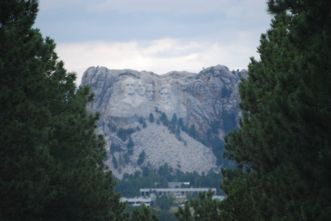
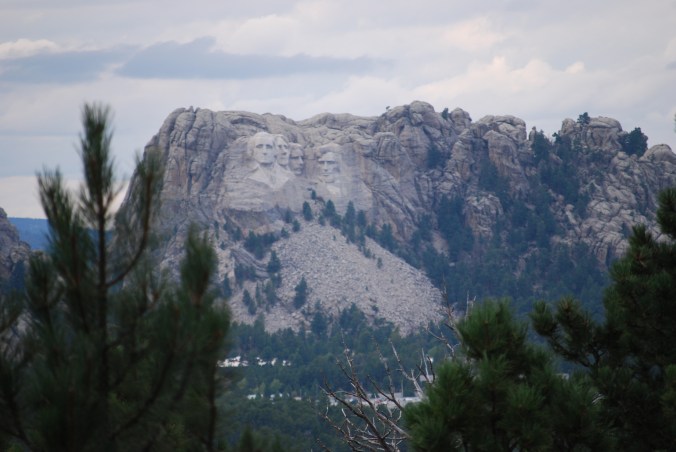
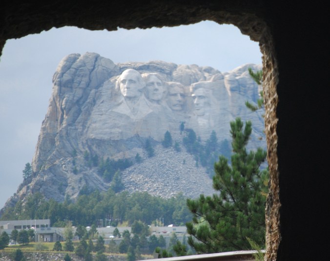
We are staying tonight in Keystone, South Dakota, which is Mount Rushmore’s home. It looks like a crazy Western Mountain Tourist Town!! Dinner tonight was at Ruby House Restaurant with drinks supplied by the Red Garter Saloon next door! Susie had Country Fried Steak, while for the second night in a row, I had Buffalo! A Buffalo Rib imageEye! Now we are back in the room, even though we should be on our way back to Mount Rushmore for the Nighttime Illumination program, but it is pouring out, 58 degrees, and heavy thunder storms are predicted for later! So, as I write this, we are here in an Econo Lodge, rather than celebrating the 100th Anniversary of the US Park Service…August 25, 1916 to August 25, 2016! Happy Birthday and good night!!

Day Four of our Big Adventure

image

It is honestly hard to believe that we are only at the end of day four, and we are sitting tonight in Wall, South Dakota! Today was a very good day, as we traveled from Minnesota to South Dakota on Interstate 90. We stopped at one ridiculous attraction, and the traveled to one of the true wonders of our trip. As we hit South Dakota, the speed limit became 80 MPH and about halfway through the state, we crossed magically from the Central time zone to the Mountain time zone. Today we traveled a total of 389 miles, and for the first time in 3 days, we didn’t come across the gray house on the Interstate! We did however come across weird animal sculptures, more wind farms, and we crossed the Missouri River!


image
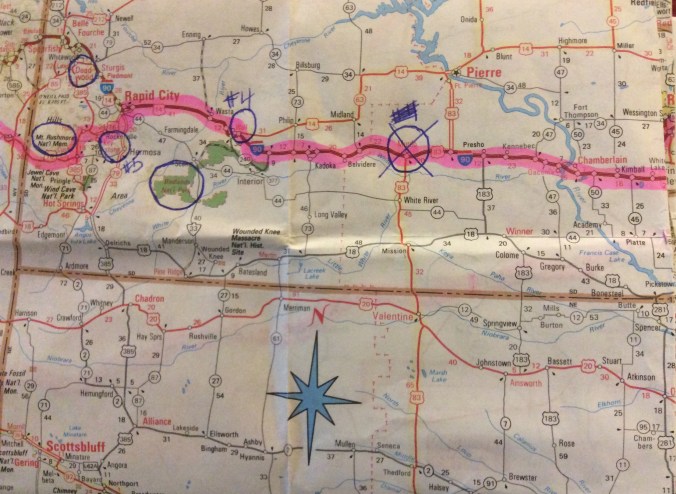
We stopped at a rest stop as soon as we crossed into South Dakota to pick up a map (well, after we hit the bathroom) and ran into one of the most incredible S. Dakota Tourism employees! Susie and I spent close to 10 minutes listening to him lay out things for us in the Black Hills, including Mount Rushmore, the Crazy Horse Memorial, Custer State Park, Deadwood, and even Devil’s Tower…which is in Wyoming! I told Susie I could have spent the whole afternoon listening to him! What a great ambassador for the state he is!

image
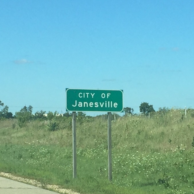
Next we headed to a place he didn’t mention, but that Susie had read about and that we’d seen signs about along the side of the road for miles. The Corn Palace in Mitchel, South Dakota! I don’t know what we expected, but what we got was a local auditorium where they play basketball and have shows (Styx is performing there tomorrow night). I guess its claim to fame is that every year the front facade is decorated with various designs that are all made of corn. Yea, I know…BFD! We were not the only disappointed folks, as Susie heard the wife of a couple that had come in with us say, “I’m sorry we came here.” I guess we should have remembered our South of the Border lessons. Too many billboards on the side of the road usually equates to a rip-off tourist attraction!

On the way to our next stop, we discovered two things. The first was that the bug screen on the front of the car didn’t like 80 MPH speed, as it blew from the front of the car, over the hood, and lodged itself over the windshield wipers. That necessitated getting of at an exit so we could reset it! We also discovered that the GPS wasn’t thrilled with 80 MPH either, as shortly after the bug screen incident, it jumped off the dashboard! The things we are learning on this trip!!

Now, our second stop of the day was something that caused both of us to say “Wow!!” the first time we got out of the car! I’m talking about the Badlands National Park! The first wow is that I got my National Park Senior Pass. $10 for lifetime admissions to the National Park system! That will save us some money in the coming weeks! Then there was just the sights that we took in. Just like when we visit Red Rock Canyon outside of Vegas, there was an incredible quiet that seems reverent, as well it should be! Hard to describe the awe inspiring views, so I’ll just let some pictures tell the tale. As they say, a picture is worth a thousand words!


This slideshow requires JavaScript.


As I said, we are in Wall tonight, home of the famous Wall Drugs. I think this is kind of like the South Dakota version of South Carolina’s South of the Border. Having just come back from there, it appears that the little roadside store that existed on whatever the road was before Interstate 90 blew through town, has grown into a 2 block enterprise. Wall Drugs, Wall Western Shop, Wall Cafe, Wall blah blah blah! We happened to have eaten in one of the many “Wallville” enterprises, the Badlands Saloon and Grill! We both had buffalo burgers, and enjoyed them. The rest of the block may be schlock, but the burgers were good and the beers were cold!! A perfect end to day four!!

Tomorrow…Mount Rushmore!!

Day Three


image

So the highlight of today was our visit to the Spam Museum in Austin, Minnesota. What else is there to say, after you’ve seen the Spam Museum?? So, see you tomorrow!

Oh, you want more? Ok, if you insist!

We stayed last night at a great Comfort Inn in De Forest, Wisconsin. Great room, wonderful lobby, incredible free breakfast this morning, what could be better? A wifi system that worked! Strange but true in the year 2016, but the average time you could stay on the internet with any device was about 45 seconds! Just as you got to where you wanted to be, you got a NOT CONNECTED message! Can you say frustrating????

We left De Forest and headed onto the interstate about 9 AM. We knew that today would not be as mileage intensive a day as the past two were, and of course we were rewarded with near perfect highway conditions. In other words, NO CONSTRUCTION!!! So much nicer to drive at the speed limit (or slightly above) and not have to spend miles in single file traffic!! We started this morning in Wisconsin, and are ending our day in Minnesota, so only 2 states today! Right now we are in a very nice Super 8 motel in Jackson. We might have pushed our travels a little further but for two factors. #1 is that we have reservations tomorrow night in Murdo, South Dakota (the first of our pre-planned reservations) and didn’t want to get too far ahead of the plan we made before leaving home. #2 is that the longer we drove this afternoon, the darker it got and the closer we got to rain. Susie looked at the radar on her iPhone and it didn’t look friendly, so we figured what better place to wait out the storm, but a nice dry motel with a Sailor Jerry Rum and Diet Coke in our hand. There’s a Burger King right down the road and in a couple of hours we’ll decide what’s for dinner, but for now, we are happy to be out of the storm. This is Tornado country, isn’t it? Total mileage today, 324 miles and we pulled in at about 4 PM Central time.

image

imageSo, lets get back to today’s highlight, the Spam Museum! Austin, Minnesota is the headquarters of the Hormel Company, the makers of Spam. The lady we signed in with told us that this was a brand new Spam Museum that just opened in April of this year, and we enjoyed spending about an hour wandering around the various exhibits. There was Spam in the World, Spam and the Military, a look at the history of the Hormel Company, and lots and lots of Spam memorabilia! In addition there were hundreds of Spam cans, including several imagewalls made of cans, showing the various flavors of Spam…even more than we saw a couple of years ago in Hawaii! They even have a Spam Gift Shop! There you could buy everything from Spam Clothes (no thanks Susie, I really don’t need a Spam Hoodie) to Spam Mouse Pads, to Spam Key Chains, to a case of Mixed Spam! We left with only a post card (to send to a restauranteur friend at home), a couple of presents for the Grandkids, and a can of Spam Spread we wanted to try! It was a cool place, and downtown Austin looked like a very typical Midwest small town! What can I tell you. It was our first “tourist” thing we did on the trip, and we enjoyed it…just like we enjoy Spam!!

image

imageAfter Austin, our next stop on today’s tour was in Blue Earth, Minnesota. Blue Earth has a couple of memorable things it hangs it’s hat on. First, the east and west crews working on Interstate 90 in the 70s met up near Blue Earth. There is a Golden Stripe on the highway there, kind of like the Golden Spike on the Trans-Continental Railway. Second, it is the home of the Jolly Green Giant. No, not the frozen vegetable company, they used to have a canning plant there, but it now has new owners. No, I’m talking about the 55 foot tall Green Giant Statue that has stood in Blue Earth since 1979! Turns out it was the idea of the guy that owned the local radio station (of course it was), and the statue has spawned a Giant Museum and a Giant Days Festival. All I can say, is that winters are long and hard in this section of the country, and they have lots of time to plan!

Susie said that between our visit to the Spam Museum and the Jolly Green Giant, we’d had our protein and vegetables for the day! I guess we would have had to venture south into Iowa to get our carbs, but who knows what form their potato worship might take???

imageThere you have the highlights of day three of our Big Adventure. We are still having fun and seeing interesting parts of the country. Like acres and acres for miles and miles of fields of corn on the sides of Interstate 90 today! We also ran into a couple of wind farms, with windmills on both sides of the highway, as far as you could see. Very interesting and much more like the wind farms we saw around Palm Springs, California a couple of years ago, rather than the 5 windmills we see in Atlantic City back home.

Our plan for tomorrow is to head out of Minnesota, and enter South Dakota. Either tomorrow or the next day, we will enter the first of many National Parks we will be visiting (Black Hills National Park) and then we will see one of my Bucket List attractions…Mount Rushmore! Our days ahead will be filled with visits to Rushmore, Devils Tower (remember Close Encounters?), Little Big Horn Battle Site, Yellowstone Park, and the Grand Tetons. Much more sightseeing, and less mileage. We will end week one of the trip in Yellowstone!

Oh and before we leave you for today, guess who we ran into again today! The house we passed yesterday in Illinois, we passed again today in Wisconsin! We are not sure if we’re following it, or it’s following us!!

image
See you tomorrow!


Day Two

image

Good evening and welcome to the Comfort Inn and Suites in DeForest, Wisconsin. We left our hotel in Streetsboro, Ohio this morning a little after 8:30. During the course of the day we traveled from Ohio, to Indiana, to Illinois, to Wisconsin…another 4 state day for us. We pulled into the hotel tonight right around 4:45 PM. Not bad for a 503 mile day! Oh, if you’re trying to do the math on that, and came up with an average speed for us of like 98 MPH, you need one more piece of information. As we crossed from Indiana into Illinois, we also crossed from the Eastern time zone to the Central time zone. Our 4:45 arrival was really 5:45 in our former time zone!

Today we also left our old friend Route 80 and transitioned to Interstate 90, which will be our home for the next several days. We left the hotel without partaking in their free “Continental Breakfast” this morning, and during one of our driver switches/bathroom breaks, Susie dug out our usual beach snack, cheese crackers. It was only then that she discovered that she bought the wrong ones for herself. Rather than peanut butter on cheese crackers, we had cheese on cheese crackers. Oh well, next purchase we’ll get it right! Lunch was at a rest area and was one of our staples on any road trip…ham and cheese rollups and Ritz crackers. Snacks were very nice Strawberry Twizzlers..one of our favorite car snacks!

A couple of words on the roads we traveled today. The first is that obviously the word for today is CONSTRUCTION. Well, really it’s two words, Road Construction! It appears that most of the roads in the Midwest are getting repaired or totally rebuilt! From the Ohio Turnpike, to the Indiana Toll Road, right through Illinois and Wisconsin. Mile after mile of “Road Work Ahead” signs. Even some that were just feet after an “End Roadwork” sign! Oh my God!!!

The second thing we must say about our travels today is that the state of Indiana should be ashamed for what they laughingly call the Indiana Toll Road! What a horrible mess!! Mile after mile under construction with only one lane open and with a 45 MPH speed limit. (Which ultimately became 35-40 MPH due to trucks driving uphill!). Then the rest areas…two out of the four don’t exist! Signs that say “Rest Area Closed” as you come to the exit for the alleged rest area. Roads going off and coming back on, but then nothing. They apparently just obliterated any trace of the rest area…buildings, gas stations, parking places. Don’t know if this is the way Indiana “re-builds”, but it really puts a crimp in your plans if you want to switch drivers or God forbid, need to go to the bathroom!!!! The real stick in the eye is that even though this is Interstate 80, YOU PAY TO DRIVE ON THIS ROAD!!! We ended up adding close to an hour to our travels today thanks to the condition of this road! We really should have known what was ahead when the “Welcome to Indiana” sign was missing, and we were greeted by two naked poles as we entered the state!

imageSo today Susie ended up driving through Chicago, thanks to the fact that the last rest area on the Indiana Toll Road was CLOSED!! The last time we were in Chicago was a couple of years ago when youngest son Kenny was working at the Wagon Wheel Theater in Warsaw, Indiana doing the Jean Shepard show, Christmas Story, the Musical. That was the time we stupidly attempted to see the house my Grandparents lived in on the South Side of Chicago, and thought we were going to die for our efforts. Today we just went through the city on the Interstate and kept on going…as well as we could with the road construction!!!

imageToday was real Kenny day, because just before our day ended we drove by another one of Kenny’s stops, Janesville, Wisconsin. A couple of years ago, Kenny did two shows at the Armory Theater in Janesville, Wedding Singer and Miracle on 34th Street. That year. the whole family (Krissi, Billy and Lori…there were no little D’Elias yet) traveled to see him in Wedding Singer in October, and then just Susie and I came back in December to see him in Miracle on 34th Street. So between those trips, and a trip Susie and I made before we even had kids, to the Midwest and the Wisconsin Dells, we’ve been here before!

As we left the state of Illinois and entered Wisconsin, we also left EzPass territory. As of tomorrow, any tolls we come across until we are back on the East Coast will be paid in hard cash! Tomorrow we enter new territory, and if plans go right, tomorrow night you can read about our visit to the Spam Museum!!!

image

imageDinner tonight was at a place called Norske Nook Restaurant imageand Bakery. Since we are in Wisconsin, we had to start with Fried Cheese Curds! We both had great looking sandwiches on bread that they make right on the premises. The list of pies (as you can see above) is extensive. A couple of to-go pieces somehow ended up in the car. We will report tomorrow!

Two pictures before we leave you tonight. It was Boat Day on Interstate 80 today. Here are both ends of the spectrum!

imageimage

Oh, and we came across a house on the road, when Susie was driving today!!!

image

See you tomorrow!!

Our Big Adventure, Day One

image

So, the end of day one on the road finds us in the Econo Lodge in Streetsboro, Ohio! We left the house in Mineola at 8:20 this morning, made a stop in Astoria to drop off our daughter Krissi (she came on Friday night to spend the last weekend with us), and then it was over the Triboro Bridge (or the RFK if you choose to use it’s new name), up the Major Deegan Expressway to the George Washington Bridge, and onto Interstate 80, where we spent the entire day. We drove up to the hotel at about 5:10, so not a bad day of driving at all. We went from New York, to New Jersey, to Pennsylvania, and now Ohio. Four states in day one and we drove a total of 451 miles and are are still on our first tank of gas!

The weather was sunny when we left Long Island this morning, and there were occasional sprinkles all through New Jersey, but when we got to Pennsylvania, boy did it start raining! We stopped at a rest area to use the bathroom, and took a shower at the same time. I felt bad because Susie was driving through a lot of it, and on a couple of occasions, it was almost like a switch was flipped as we went from showers to torrential rain in the blink of an eye! Not fun to drive through! Then we came upon an accident in one of the more mountainous regions of Pennsylvania. Some yahoo in a pickup truck was sideways off the road (I say yahoo, because rain or shine, we see folks driving like they are late for their wedding and not giving a damn about safety). There were Police and a wrecker already there, but as we were 3 cars from the accident, they stopped all traffic so that the wrecker could pull the truck back on the road. We sat there for better than 15 minutes…in the rain…such fun!

imageSome highlights of today…First breakfast. We chose to stop at a place we have eaten at more times than we can count, the Landmark Diner just off exit 309 of I-80 in Pennsylvania. This place has a lot of history in our family, and in Susie’s family before there was an us. For years and years, Sue’s Mom and Dad would spend a week at a golf resort in Marshall’s Creek, PA called Mountain Manor. Over the years, they made good friends who also vacationed there during the same week and who lived near them on Long Island. The Landmark Diner was about 2 hours from Long Island, and they would all rendezvous there on the morning they checked in, and have breakfast. Year after year, more folks would join in the group, and eventually we were part of the group who would have breakfast at the Landmark. The summer of 1983, we took a very young Billy there and Frank’s folks even joined the group! When Kenny and Krissi joined our family, we would still head up to that area and always stop there, Turn the clock ahead a few years to when Billy was going to Ithaca College in Ithaca, NY. We discovered the best way to get there was to head out Route 80 to Pennsylvania and then go north back into New York State, and yes, then too we would pull off 80 as soon as we crossed the Delaware Water Gap Bridge and have breakfast. Susie thinks that the last time we were there was about 4 or 5 years ago, and we were thrilled to find this morning that it was just as good as we remember! Susie had Creamed Chipped Beef over toast (probably the last time we see that on a menu) and I had a Pulled Pork Omelette! Oh, and don’t forget the home fries….they are still wonderful! The restaurant is a little bigger, the counter is gone (where you could watch them cook the food) and the bathrooms are no longer behind the building, but enough is the same to still make it a special stop off!

Then we were back onto Interstate 80 West heading towards our adventure! At mile marker 111(FYI..at the NJ/Penn border on 80 you are at mile marker 310 and at the Penn/Ohio border you are at mile marker 0) we came across an interesting sign. It said, “You are now at the highest point on Route 80 east of the Mississippi – Elevation 2,250 Feet”. Impressive for Pennsylvania, but not where we are going. Forget the Rocky Mountains or even Pikes Peak, when we are at Mount Rushmore this Friday we will be at 4000 + feet already! Start storing oxygen now!!

So dinner tonight was at Ruby Tuesdays, a place we haven’t been to for years. Even though there is one less than 2 miles from our house in Mineola, we traveled 450+ imagemiles for their salad bar tonight! Then we filled the car up with gas (Sheetz Gas…I kid you not) at $1.95 a gallon, headed back to the hotel and are relaxing with some vodka on the rocks (in our travel plastic cups!)! Tomorrow we hope to cover just under 500 miles and stop near Janesville, Wisconsin…a place we’ve visited before when Kenny was performing at the Armory Theater there.

imageOh, The Big Adventure tip of the day has to do with an App that my cousins, Jeanne and Walt Pratt shared with us called iExit. It cost me 99 cents at the iTunes store, and Jeanne and Walt said it was useful finding what kinds of food, gas, hotels, etc. are at every exit on the interstates. In addition, it gives you the latest prices for gas at the various stations so you always know what you are getting into. When we started trying it out today, Susie started talking about a little hand held digital gadget we had way back in the 90s. After you told it what road you were on, what mile marker you were near, and what direction you were heading, it would tell you how close the next rest stop was and what services they had there. She said it’s too bad they don’t make an App for that. Well, I hit a couple of buttons on iExit and discovered it will also search for rest areas! It was perfect, and we made use of it several times today looking for places to switch drivers. Thanks Jeanne and Walt…welcome along!

On the Road Again…….https://www.youtube.com/watch?v=NvwojnLeMH4


The Number One Question We Get Asked

We honestly thought that the next time you heard from us, we’d probably be on the road, or just about to start our Big Adventure, but because we keep getting asked the same question over and over again, we thought it might be worth exploring the question, our answer, and our reasoning. For as long as we have been contemplating and talking about this trip, almost every time it comes up in conversation, we get asked this question. In fact, just yesterday, at a lunch with some former workmates Sue was asked it, while at almost exactly the same time, Frank was asked it by our Dentist. Invariably, as we are talking about our route and some of the stops we’re making, someone pipes up and says, “So are you renting a Motorhome for the trip?” Our answer is always the same, “Nope…we’re going in our 2013 Hyundai Sonata Limited and staying in hotels.” Sometimes you see a little disappointment at our answer, because I guess this is the kind of trip many see doing in a Motorhome, but for us, it’s just not what we’re looking to do, and here’s why.

PRICE

Here’s the first downer for using a Motorhome, unless you already own one, the cost of rental. They are not cheap vehicles to rent! From research we’ve done, it looks like a smaller Motorhome, that would be perfect for 2 people rents for around $100 a day. Then, there is a fee of 35 cents per mile driven, plus it gets about 9 miles to a gallon of gas. On the other hand, our 2013 Sonata with 47,000 miles on it is fully paid for. Any service costs that we’d have to pay in preparation or during the course of our trip would be normal wear and tear items that we’d already have to pay for, and it will get close to 35 MPG on the highway all day. “But you’ll save the cost of hotels in the Motorhome”, you might say. Well, lets take a day out of our trip and compare the costs of the two styles of travel, and you decide.

For argument sake, lets take a day when we travel 300 miles and as a stop, let’s talk about our visit to Mount Rushmore in South Dakota.

imageMotorhome

Daily Rental………………………………$100
Mileage Fee………………………………$105 (35 cents X 300 miles)
Cost of Gas……………………………….$ 75 (300 miles @ 9 MPG X $2.25 a gallon)
Campground………………………………$ 63 (KOA Hill City, SD)

Motorhome Total……………………………..$343


imageSonata

Daily Rental……………………….$000
Mileage Fee……………………….$000
Cost of Gas………………………..$ 22.50 (300 miles @ 30 MPG X $2.25 a gallon)
Hotel……………………………………$ 86.51 (Econolodge, Keystone, SD)


Sonata Total…………………………….$109.01

Some might try and throw in the expense of food, but as we already travel with our cooler and supplies for breakfast and lunch, the only meal you might be able to argue about would be dinner, and we’d bet the difference there would not be enough to tip the balance towards renting a Motorhome. Add in the fact that our current plan is to be on the road at the very least 2 months, and to cover upwards of 6,000 miles, and you can see just how much the Motorhome would cost us in terms of daily rental, mileage charge, and gas! Score one for the car!

CONVENIENCE

Ever notice that when you see a Motorhome driving down the highway, if it’s an owned Motorhome and not a rental, it’s almost always towing a car or some motor bikes on a trailer? That’s because if they didn’t have this other form of transportation along for the ride, every time you’d go anywhere, you’d have to take your home with you! Think about it. You stop for the night at that KOA Camp Ground near Mt. Rushmore we used in the price example. We’re staying two nights in the area because there’s a lot to see, so let’s assume we’re doing the same renting a Motorhome. That first night you pull in, get the unit level, hook up the electric service, the water, the cable TV, and you settle in for the night. The next morning you’re off to Mt. Rushmore and what do you have to do? Yep, unhook the water, electric, cable TV, put away anything and everything you took out of it’s storage the night before, and like the turtle, head off to Mt. Rushmore with your house on your back. Then you get to Mt. Rushmore, and you’re not looking to park a car, but a Motorhome. Everything we’ve read, parking for a Motorhome at a lot of these sites is limited, and in many instances far away. We’ve also read that in places like Yellowstone National Park, it’s even a bigger pain to try touring in a Motorhome. But say you do have a successful day touring around the Mt. Rushmore area with your rented Motorhome. When you are done for the day, do you get to open the door of your hotel room and flop on the bed? Nope, you have to start the hookup procedure all over! And what about any cities that may be on your itinerary? How convenient do you think it’s going to be going around Denver or Salt Lake, or even Las Vegas in a Motorhome? All reasons that we think the car wins again.

LOCATION

You know the old Real Estate adage, Location, Location, Location. Well, when you are talking about campgrounds where you can spend the night in a rented Motorhome, it also comes into play. Campgrounds need lots of space, and because of that, are often farther afield from tourist destinations than hotels. In the Mt. Rushmore example we used earlier, the hotel we have reservations for is a mere 8 minutes from Mt. Rushmore, while that KOA we used as an example is 30 minutes away. The more populated the area, the bigger that time difference. You can stay in a hotel in Denver or Salt Lake, but a campground will probably be well outside the area that you wish to see, which will mean added travel time, and then the nightmare of trying to park the Motorhome! Some may disagree, but for us, another win for the car!

BEEN THERE, DONE THAT

Back when the kids were young, we owned a succession of pop-up campers. For about 6 or 7 years, we towed the pop-up behind our van. Many times, it was to return to a known campground where we went every summer, but there were also sightseeing trips that we went on. One year, it was up to Mystic, Connecticut, another year a 10 day journey through New York State and into Canada. On those sightseeing trips, most days we stayed one night in a location, so each afternoon it was set up the camper, and the next morning it was pack it up. Different campgrounds every day, setting up and knocking down daily, dealing with dirt and campground bathrooms, finding parking at tourist sights for our van/camper combo, driving down the road with a vehicle that was more affected by wind and the force of passing tractor trailers than a car….we’ve been there, and done that. It was great back when we did it, and it may be great for many people today too, but it’s just not what we want on this trip. Once again, for us, and based on past experience, the car wins out!

So, no, we’re not renting a Motorhome for our Big Adventure. We will be driving our Sonata, staying in a succession of national chain hotels, and National Park hotels, and enjoying clean sheets and good air-conditioning (or heat) every night! Nothing against Motorhomes and if your own one, we’re sure that they are a great way to travel, but it’s not just for us! The trip itself is going to be a Big Adventure enough for us, without adding the cost and inconvenience of a rented Motorhome. We’re just not prepared for that Big an Adventure!

Hope that answered your question.

Knowing and Using Your Resources

As the calendar pages turn from July to August, our days in Ocean City get down to a handful, and the start of our “Big Adventure” is just weeks away! Once we get back to Long Island next weekend, we’ll have a couple of weeks to get clothes together, schedule the car to be checked out, take care of visits to the Doctor and Dentist, take care of nail and hair appointments, and see our kids before we leave. Then on Sunday, August 21st, with the car loaded, off we will go. A combination of sadness (that we are leaving the life we love in Ocean City), excitement (that this trip we have so long dreamed about and planned is really here), and trepidation (are we nuts to embark on 2-3 months of driving around the United States????) is our current state of mind, but we know that once we get on the road, we’ll have a great time!

Recently, a friend who has been following along with this blog asked a question about where to get information. He too wants to embark on a retirement trip, but he just didn’t really know where to start. It started us thinking about what our process has been, and thought some might find it interesting to take a look at some of the tools we have used along the way. This is by no means a comprehensive list, but just some ideas we have used to get a handle on some of the places we want to visit and how to get there.

image
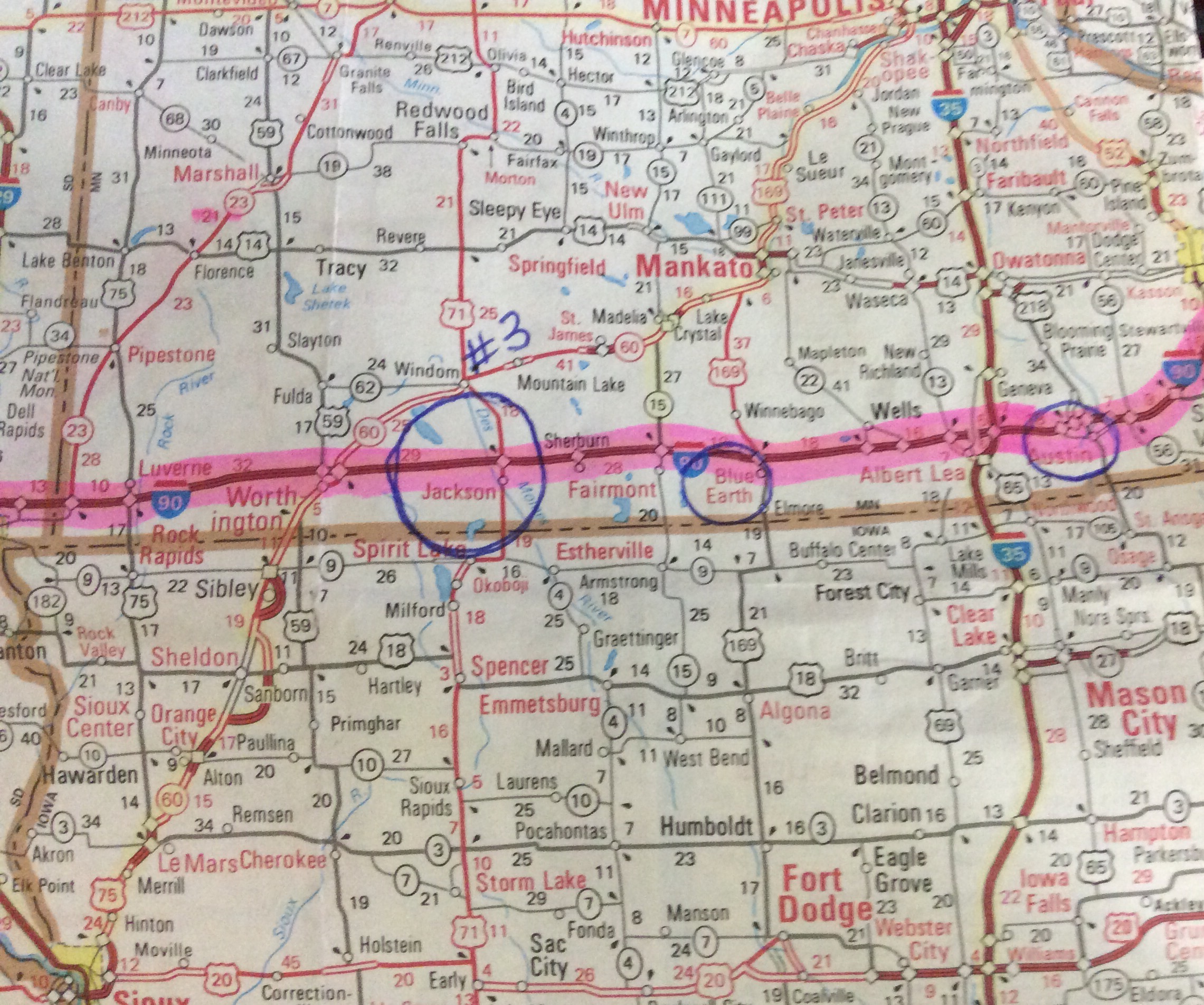
1 – The AAA. As long time members of the American Automobile Club, we have always used AAA Maps and Tour Books as our road trip bibles. If you are of a certain age, you will understand what we mean when we say there is just something about watching your progress on a paper map that seems to define a road trip. Luckily, some of the best paper maps you can get, are published by the AAA, and are a perk of your membership. In addition to the maps, the tour books have a wealth of knowledge about tourist destinations as well as hotel and restaurants listings in the area. If you are an AAA member, you can order maps, tour books and even triptiks (route directions) online. You can also just stop into a local AAA office (doesn’t have to be the state AAA you are affiliated with) and pick up maps, tour books, and even triptiks. Having a paper map in front of you so that you can check the location and relationships between places you want to visit is a must when planning a trip, and the tour books will give you valuable information about the places on your trip and be very helpful in deciding what you want to visit. If you are a member, stop in and pick up a couple of maps and tour books and start planning. If you are not a member, consider joining, as the price of your membership will be well worth it for the information you can get. (aaa.com….yearly membership $52)

image2 – Atlas – Because many people would not consider a road trip without a comprehensive road atlas, we purchased a Rand McNally Road Atlas. This one volume contains maps of all 50 states and lower Canada and assures us that we will always have a map showing our location, wherever we are in the US. The scale is smaller than the AAA maps which sometimes makes it hard to figure out exactly what you’re looking at, but sometimes makes it easier to see the relationship between two destinations. While we’ve used this volume a lot in our planning, for our actual trip we think it will take a back up roll to the bigger scale AAA maps.

image
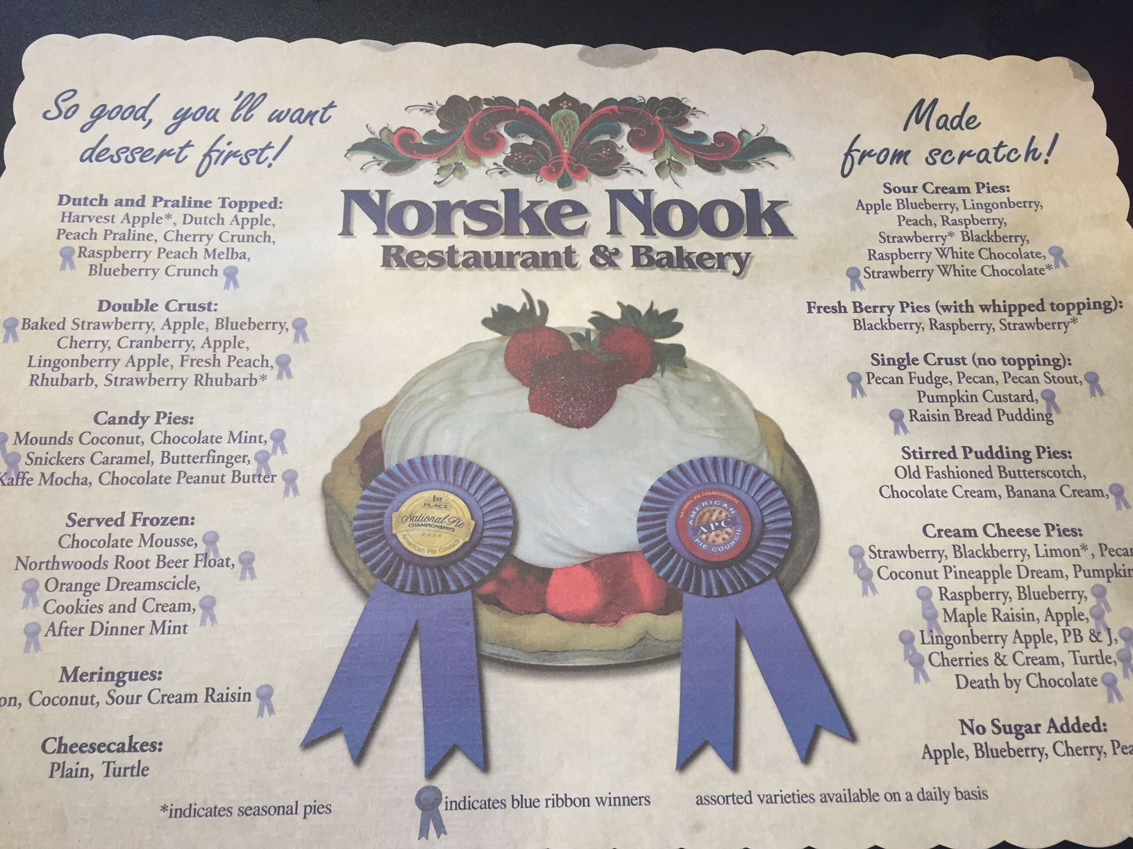
3 – Books – One of the things that you need to do when you are planning a road trip, is to decide what you want to see. If you have a “bucket list” of places that you want to include (like Frank wants to see Mt. Rushmore and Sue Yellowstone and the Grand Canyon), it will make your planning easier, as you already will have destinations in mind. If your “bucket list” is empty, or if you need more information about places, there are thousands of travel books you can purchase via Amazon or at a book store like Barnes and Noble that will help you flesh out an itinerary. Two that we have used are, “1,000 Places to See in the US and Canada Before You Die” (Workman Publishing, NY) and The New Roadside America (a Fireside Book published by Simon and Schuster, NY). The first covers everything from National Parks, historic sites, scenic byways, and the like, while the second will lead you to the odd things…like the biggest thermometer, ball of twine and those kind of offbeat attractions.

image

4 – Google and the Internet – We live in the age of information at our fingertips, and much of the info you’ll want to plan your trip is available via your computer, tablet, or even smart phone. Google will lead you to just about anything you have a question about, and virtually everything has a website these days. Want more info on the Grand Canyon? Type it into Google and go right to the Grand Canyon National Park’s website. While it’s nice to have books in hand, the reality is that you can find everything you need on the internet.
image

5 – Trip Advisor – While we are talking about web sites, we’d like to single out one that has provided us with lots of information and advice. Trip Advisor (www.tripadvisor.com) is virtually a one stop destination for travel information. From hotel, restaurant, and attraction reviews, to information about the area, even to listings of hotel and apartment rentals, Trip Advisor is a great source for travel information. Just put in the area you are interested in visiting, and Trip Advisor will provide you a complete overview. In addition, hit the MORE button on the top of the page, highlight TRAVEL FORUM and it will open up the Travel Board where you can ask questions and get real advice from fellow travelers! From Cities and States, to National Parks and Historic Sites, to every kind of trip (like Road Trips), you can find a forum that covers exactly what you are looking for, populated with knowledgeable travelers looking to help their fellow travelers. A great resource.

image6 – Google Maps – Looking at places on a map gives you an idea of where they are and the relationship of places to each other, but how do you know how long it will take you to get from say Chicago to the Black Hills? This was the position we were in when planning some sections of our trip, and we found an easy way to get a ball park estimate was to use Google Maps. Enter your starting point and your destination, ask for directions, and it will tell you not only the mileage but give you an idea of the driving time. Now, we know that it’s not fool proof, but we think it’s a good way to get an estimate so that you can make some decisions based on facts.

7 – Hotel Apps – If you have a smart phone or a tablet you can travel with, hotel apps are a great way to see what’s available and even to make reservations. At the present time, I have apps from Best Western, Hilton Honors, and Choice Hotels on my phone, but there are many others. If you’re going to be traveling a lot, not only do these apps help you find lodging, but by joining their programs, you may even get free stays!

image6- GPS – While we like printed maps, we always travel with a Garmin GPS on our dash. It’s very handy when you are trying to find a hotel or site that you have an address for, and good to give you an idea exactly where you are. In addition, ours tells us what the local speed limit is, how fast we’re going, and also keeps us updated on traffic. We don’t depend on it totally, as we always try to have maps as a reference, and I’ve read on the internet that using a GPS in the American Southwest is iffy at best, as they are notoriously inaccurate there for some reason, but it’s a good tool to have in your tool box.

So there it is…some ideas from us, and how to go about planning and executing your trip of a lifetime…or perhaps just a trip down to Florida in the winter to avoid the January and February freeze! Probably the next time you hear from us, we will be on the road, but now we have to continue packing up the Ocean City house, and get ready for 2 weeks of trip preparation!